Florida Historical Marker List
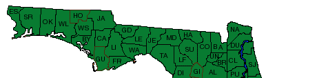
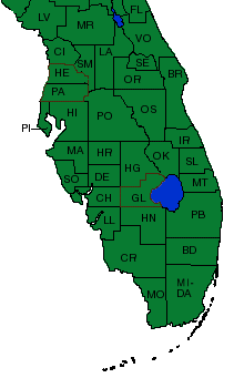
You may enter keywords, enter a city, and select a county from the drop-down menu. Any combination will work. You may also click on the map of Florida to view information on historical markers for a particular county in Florida.
Currently, not all markers and texts are included. All marker information is being added and should be available soon. Thank you for your patience.
You can also try out our Interactive Map
City: St. Cloud
County: Osceola
Year: 2020
Location: 1107 Massachusetts Avenue
City: St. Cloud
County: Osceola
Year: 2018
Location: 1029 New York Avenue
City: St. Cloud
County: Osceola
Year: 1963
Location: 2700 Lake Shore Blvd
City: Kissimmee
County: Osceola
Year: 1983
Location: 2 Courthouse Sq, on grounds of Courthouse.
City: Yeehaw Junction
County: Osceola
Year: 1996
Location: State Highway 441 and State Road 60.
City: St. Cloud
County: Osceola
Year: 1986
Location: 13th St. Between New York and Pennsylvania Ave.
City: Kenansville
County: Osceola
Year: 2009
Location: 1180 South Canoe Creek Road
City: St. Cloud
County: Osceola
Year: 2015
Location: 1200 New York Avenue
City: St. Cloud
County: Osceola
Year: 2015
Location: 915 New York Avenue
City: St. Cloud
County: Osceola
Year: 2016
Location: 1012 Massachusetts Avenue
City: St. Cloud
County: Osceola
Year: 2017
Location: 1101 Massachusetts Avenue
City: Kissimmee
County: Osceola
Year: 2018
Location: 1709 North John young Parkway
City: St. Cloud
County: Osceola
Year: 2019
Location: 10th Street
City: Saint Cloud
County: Osceola
Year: 2023
Location: 5200 Jones Road
City: St. Cloud
County: Osceola
Year: 2024
Location: 1201 13th Street